Alert

The lake is being maintained at a low level for dam assessment and repair. Any water level rise is followed by a fast drawdown.

All ramps are blocked off except for the gravel one into the north river channel at Hwy 51 landing parking lot. How far you can go there is limited by river flow and/or lake level. Creek and riverbank fishing are other options.

For COE regulations, see: US Army Corps of Engineers

Date and Time Updated:
Species

Fish

Some folks are bank or kayak fishing for fish concentrated in creek and river pools. Catfish have been biting in the creeks and river. It's a little early for white bass. Use baits and lures appropriate for your target fish (ex. soft plastics for bass, jigs for crappie, natural baits for catfish).

All fishing regulations remain in effect. It is a good time to take pictures or waypoints of bottom cover or habitat for when the lake refills. Be very careful around steep, muddy banks or soft bottomed areas. Some fish should survive in the main lake, sloughs, and in deeper holes in creek and river channels.

Winter fishing can be good since the fish often school tightly and/or are concentrated by low water. Fish bite better after a few warm, sunny days. Unlike summer, best bet is to fish midday on sunny banks. Check water level trends; except for catfish, fishing is usually better on a slow fall than a fast rise. Even in cold weather, catfish will feed in rainfall runoff. 

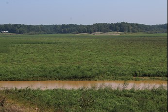
The extended drawdown is allowing vegetation to colonize exposed areas, providing habitat, cover, and food for fish, aquatic invertebrates, waterfowl and other wildlife when re-flooded. Flooded vegetation also settles sediment out of the water. 

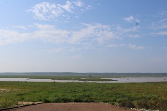
Views from Hernando Point ramp (bottom left) and across Hurricane Creek bottom Sept 7 (bottom right).


Special Fishing Regulations


SpeciesRegulation TypeLength To Release
Crappie (combined black and white)Minimum length limit12 inches and under
Creel Limits (per person, per day)
TypeAmountAdditional Information
Crappie (combined white and black)15There is a 40 crappie per boat limit for boats with 3 or more anglers.

Anglers may use no more than 4 poles per person and no more than 2 hooks or lures per pole.

Statewide creel and size limits apply to all other fish species.

Spillway

The spillway area is closed to fishing because of the dam repair.

The spillway had two gates open 8.0 ft, one gate open 19.0 ft (3570 cfs), Tuesday AM. Spillway gate openings, flow rates, and spillway water elevations can be obtained at Vicksburg District Corps of Engineers OR Yazoo River Basin Reservoirs click on 24-hour change for picture explanation of gate flow, spillway flow, etc.).

Water Level

Water level 207.98 ft Tuesday AM, falling 2.1 ft/day. Expect very rapid rises and drawdowns as rain events happen and the Corps tries to maintain a low water level. Ignore the rule curve as the COE maintains how water to assess and repair the dam. Emergency spillway level is 238.3. For water level information, call (662)562-6261 or check at Vicksburg District Daily Bulletin for a table OR Coldwater River @ Arkabutla Dam, MS for a graph OR Yazoo River Basin Reservoirs for both (click on 24-hour change for picture explanation of gate flow, spillway flow, etc.) Be sure to check the date on the table: it is usually updated midday.

Additional Information

Mississippi Deparment of Wildlife, Fisheries, and Parks Fisheries Biologists use various sampling methods to assess the fish populations in the State's waters. Sampling results for selected water bodies are summarized in Reel Facts Sheets (needs link).