Date and Time Updated:

Alert

The boat ramp is open at this time.

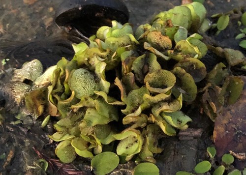
Due to the lake being drawn down to assist with the control of Giant Salvinia, the lake will experience low water levels from time to time. Please be aware of periodic low water events and please call ahead to determine if the ramp is open.

Clean your boat trailers!

Giant Salvinia is a highly invasive floating aquatic plant that has been confirmed in Lake Tom Bailey. Please remove all vegetation from your boat trailers before leaving launch areas.

Lake Tom Bailey
Species
SpeciesDetail
Largemouth BassNo new report. Bass fishing has been fair with fish being caught shallow on spinner baits.
CrappieNo new report. crappie fishing has been good with bright colored jigs working well in addition to minnows.
BreamNo new report. Bream fishing ahs been fair with red worms and crickets catching some large bluegill.
CatfishNo new report. Catfishing is fair with some large fish being caught on chicken liver.

Water temperature: 62°F

Water visibility (inches): 24 muddy

Report provided by Mr. Jason Thgpen, Central Region Lakes Supervisor

Special Fishing Regulations
SpeciesRegulation TypeLength To Release
Catfish No length limit
Creel Limits (per person, per day)
TypeAmountAdditional Information
Catfish10Creel limit for all State Fishing and state Park Lakes
  • Only rod and reel or pole fishing is allowed on State Fishing Lakes except that carp, gar, buffalo, and bowfin may be taken by use of bow and arrow at night only after purchasing a valid permit for fishing and/or boating. No other gear is allowed at these lakes.
  • Fishing is not allowed from courtesy piers adjacent to boat ramps. Night fishing is allowed from the bank or boats which are in compliance with state and coast guard regulations.

Statewide creel and size limits apply to all other fish species.

Additional Information

For information about Lake Tom Bailey, please call (601) 632-4679.

Lake Tom Bailey depth map

Mississippi Department of Wildlife, Fisheries, and Parks Fisheries Biologists use various sampling methods to assess the fish populations in the State’s waters. Sampling results for selected water bodies are summarized in Reel Facts Sheets

GPS Coordinates for brush piles that were added 1/12/16 are listed below.
N 32.42285W 88.51477N 32.42555W 88.51812
N 32.42404W 88.51488N 32.42561W 88.51801
N 32.42430W 88.51518N 32.42553W 88.51788
N 32.42508W 88.51507N 32.42570W 88.51792
N 32.42508W 88.51528N 32.42561W 88.51780
N 32.42440W 88.51548N 32.425528W 88.51798
N 32.42427W 88.51527N 32.42521W 88.51812
N 32.42352W 88.51484N 32.42564W 88.51766
N 32.42377W 88.51519N 32.42551W 88.51769
N 32.42409W 88.51606N 32. 42753W 88.51742
N 32.42399W 88.51614N 32.42510W 88.51762
N 32.42411W 88.51629N 32.42495W 88.51744
N 32.42420W 88.51608N 32.42518W 88.51726
N 32.42412W 88.51650N 32.42524W 88.51730
N 32.42398W 88.51634N 32.42522W 88.51714
N 32.42540W 88.51815N 32.42543W 88.51722
N 32.42547W 88.51802N 32.42524W 88.51759