Alert
Natchez State Park Lake is closed to the public for repairs at this time.
Natchez State Park Lake is closed to the public for repairs at this time.
| Species | Regulation Type | Length To Release |
|---|---|---|
| Black Bass (combined largemouth, spotted, and smallmouth) | Slot length limit | 18 to 22 inches |
| Catfish | No length limit |
| Type | Amount | Additional Information |
|---|---|---|
| Black Bass (combined largemouth) | 7 | Anglers can harvest only one bass over 22 inches |
| Catfish | 10 | Creel limit for all State Fishing and State Park Lakes |
For information about Natchez State Park, please call (601) 442-2658.
Natchez State Park Lake Depth Map
Mississippi Department of Wildlife, Fisheries, and Parks Fisheries Biologists use various sampling methods to assess the fish populations in the State’s waters. Sampling results for selected water bodies are summarized in Reel Facts Sheets.
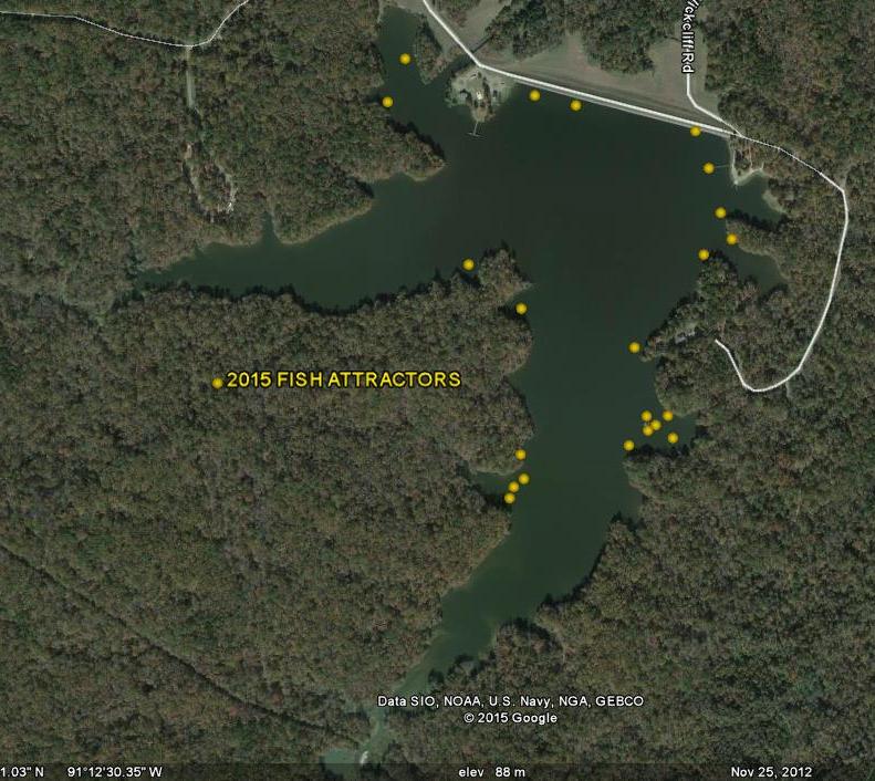
Fish attractors were added in several locations in February 2015. Be sure your GPS is set to read decimal degrees (shown below) and not degrees-minutes-seconds when attempting to locate the attractors. Coordinates and a map are shown below:
| Coordinates Below | |||
|---|---|---|---|
| N 31.595850 | W 91.203029 | N 31.597647 | W 91.203667 |
| N 31.594941 | W 91.203450 | N 31.592900 | W 91.205240 |
| N 31.590913 | W 91.204257 | N 31.590750 | W 91.205380 |
| N 31.589594 | W 91.208455 | N 31.589594 | W 91.208955 |
| N 31.589594 | W 91.208455 | N 31.589842 | W 91.208350 |
| N 31.590028 | W 91.208074 | N 31.593749 | W 91.208157 |
| N 31.594715 | W 91.209512 | N 31.598284 | W 91.211600 |
| N 31.599235 | W 91.211145 | N 31.598431 | W 91.207810 |
| N 31.598215 | W 91.206750 | N 31.591195 | W 91.204700 |
| N 31.591075 | W 91.204900 | N 31.591390 | W 91.204935 |
| N 31.596840 | W 91.203330 | ||